Survey
Fig. 1 (supplied courtesy of Placer Dome Exploration) shows the regional total-field magnetic anomaly map for an area surrounding the Mt. Milligan copper porphyry deposit. This type of airborne data set is useful for identifying-large scale regional geological trends. However, exploration for a specific deposit requires more detailed information about local subsurface distributions of rock types.
The figure inset shows the ground-based total field magnetic anomaly map over the MBX structure. The area is 1.2 x 1.0 km with data gathered on lines spaced 50 metres apart. The data were re-sampled to 25 metres spacing along the lines, and then the data set was upward continued to 20 metres. This was necessary to remove features in the data that were caused by magnetic material that was smaller than the cell size used for inversion. The ambient field was (strength, declination, inclination)
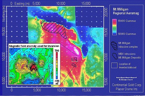
Fig. 1 Total magnetic field strength map for the Mt. Milligan region, gathered by airborne magnetic survey techniques. In the inset, the large scale regional magnetic field has been removed to emphasize the signature of anomalous subsurface magnetically susceptible rocks.